
Makgadikgadi & the Salt Pans
The pan country either side of the A3, whose calendar runs backwards relative to Chobe: the wet season is the season.
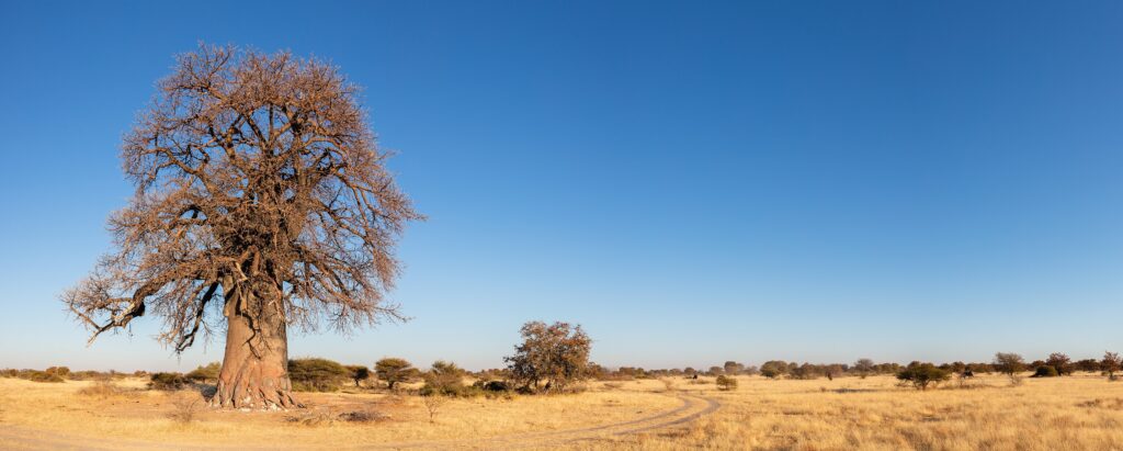
Best time to visitSelf-drive BotswanaA baobab in dry grassland in Makgadikgadi Pans National Park, Botswana. Photo: Diego Delso, CC BY-SA 4.0, via Wikimedia Commons.
The Makgadikgadi Pans are the flat, blinding heart of eastern Botswana — the bed of a vanished superlake, now salt crust, fossil grassland and acacia island across much of the Central District. Most travellers meet the region as a day of driving between Francistown, Maun and Kasane, which undersells it badly.
Why visit the Makgadikgadi Pans
Three things set this region apart from Botswana’s other destinations. Scale and emptiness: on open pan in the dry months there is no vegetation and no horizon reference, disorienting in a way nowhere in the Delta or Chobe is. Inverted seasonality: the pans are at their most alive in the green season. And movement — this is the pivot of two zebra migrations, one ending at Nxai Pan.
The complex has sat on Botswana’s UNESCO Tentative List as the “Makgadikgadi Pans Landscape” since 2010. Tentative listing signals an intention to nominate and confers no status; it is not a World Heritage Site, whatever some sources claim.
Nata: the junction almost every itinerary passes through
Nata is a small village with an outsized role. It is the junction where the A3, running west from Francistown to Maun, meets the A33, running north to Kazungula and Kasane. Francistown to Nata is roughly 180 km, Nata to Maun a further 300 km, and the A33 about 300 km north to Kazungula. Drive between any two of Francistown, Maun and Kasane and you pass through Nata — on a northern loop, probably twice.
It is therefore the standard fuel and food stop on those runs, and the last dependable fuel before Nxai Pan. Treat it as a planning anchor rather than a destination — we cover the village, the sanctuary and the onward routes on Nata. Fuel availability and opening times change; confirm locally.
Sua and Ntwetwe: the two great pans
Sua Pan (also written Sowa) lies east, nearer Nata, fed by the Nata River and also the site of a large soda ash operation. Ntwetwe Pan lies west; the Makgadikgadi reserve takes in its western end.
Both are seasonal. Dry, they are hard, cracked and drivable in places. After good rains they hold shallow water, turn soft and swallow vehicles that stray onto them. Driving onto a wet pan without a guide who knows the surface is a reliable way to ruin a trip: recovery is slow and often impossible without a second vehicle.
Kubu Island
Kubu Island is the landmark of Sua Pan’s south-western edge — a low granite outcrop crowned with baobabs, approached from the Mmatshumo side. It is 4×4 country with no services. Our sources did not cover its current access arrangements, camping bookings or any community fee, so confirm those directly.
Nata Bird Sanctuary and the Sua Pan flamingos
The Nata Bird Sanctuary is a community conservation area of about 250 km² on the northern edge of Sua Pan, opened in 1993 and a Tourism for Tomorrow award winner that year. Viewing is from hides.
The conservation literature calls the Makgadikgadi the most important breeding site in southern Africa for greater and lesser flamingos, and the numbers can be extraordinary — an aerial survey in June 2019 counted 532,197 flamingos in the northern basin of Sua Pan, feeding rather than breeding. But this is entirely conditional on the pans holding water, which depends on the rains and on inflow from the Nata River. In a poor year there may be almost nothing, so anyone guaranteeing flamingos is promising what they cannot deliver. The realistic window is roughly December to April after good rain; our wildlife section has the wider seasonal picture.
Parks and reserves
Makgadikgadi — and a naming problem
Botswana Tourism Organisation’s own page is headed “Makgadikgadi Pans Game Reserve” and gives 3,900 km²; most other references, including standard protected-area lists, say “National Park” and give closer to 4,900 km². We are not going to pick a winner: if the designation or exact area matters to you, confirm it with the Department of Wildlife and National Parks.
The reserve is bounded north by the A3, which separates it from Nxai Pan, and west by the Boteti River. Its character is grassland and acacia woodland rather than bare salt, with Stone Age sites and brown hyena among the draws. Useful routing settlements include Gweta, Mopipi, Mmatshumo, Rakops and Letlhakane. We cover the park itself — the wet-season migration, the Boteti, access and what you need to drive — on Makgadikgadi Pans National Park.
Nxai Pan National Park and Baines’ Baobabs
Nxai Pan lies north of the A3 and is the most accessible part of the greater complex. BTO gives 2,100 km², other references around 2,578 km² — another discrepancy to handle with care. It holds three main pans: Nxai Pan itself, Kgama-Kgama and Kudiakam, ancient salt lakes now grassed and studded with acacia islands. We cover the park in full — the wildlife list, the season, Baines’ Baobabs and the approach — on Nxai Pan National Park.
Access is unusually good for Botswana: a single entrance gate roughly 130 km from Maun and 65 km west of Gweta, with tar right up to the gate. Inside, that ends abruptly — a 4×4 is essential, sand is soft, corrugations punishing, and from December to April sections can be very muddy, worst in the north. There is no fuel in the park; refuel at Nata, Orapa or Rakops.
Baines’ Baobabs — a cluster of seven ancient trees on the edge of Kudiakam Pan — lie roughly 30 km from the Nxai Pan entrance, reached on sand track. Wildlife includes zebra, wildebeest, springbok, gemsbok, hartebeest and giraffe, with lion, cheetah, wild dog and brown hyena present; artificial waterholes hold game year-round, though the park is at its best after good rains. See our parks and reserves section for protected-area context.
Two zebra movements, routinely confused
Botswana has two separately documented long-distance zebra migrations, involving different animals in different parts of the country. Travel writing conflates them constantly.
- The Makgadikgadi–Boteti movement. Zebra move between the Okavango Delta periphery and the Makgadikgadi grasslands, some routing via the Boteti River — a round trip of roughly 588 km, out with the rains around November and back in April–May. A veterinary cordon fence severed the route from 1968 to 2004; the migration re-established itself once the fence came down. Why some Delta zebra migrate and others stay resident is not known, and confident talk of ancestral memory is speculation, not published finding.
- The Chobe–Nxai Pan movement. A separate population moves from the Chobe River floodplains south to Nxai Pan — a straight-line round trip of about 500 km. Tracked animals left in December, most arriving between 14 and 27 December, stayed roughly ten weeks, and took a mean of 85 days returning against 15 days southbound. It is often billed as Africa’s longest migration; that claim is disputed in the literature and turns on which metric you use.
One correction matters for planning. The dry-season zebra concentration on the Boteti is not the migration. What you see from roughly July to October is animals pinned to the last permanent water — an aggregation. A fine sight, and a different phenomenon from the November departure and the March–May return.
Activities
Beyond game drives, the signature activities are pan-based and mostly run by lodges and concessions rather than open to independent travellers: quad biking, sleep-outs and sundowners on the open salt, and walks with habituated meerkat groups.
One accuracy point on the meerkats. The habituated groups are at private concessions in the Makgadikgadi. They are not the Kalahari Meerkat Project — that study, behind most published meerkat science and the television people remember, is at the Kalahari Research Centre in the Kuruman River Reserve in northern South Africa. The Botswana experience is excellent on its own terms; it is simply a different thing. Dry-season mornings, as groups emerge to warm up, are the reliable time.
Access and self-drive context
The region is well served by tar by Botswana’s standards: the A3 crosses it east to west, and the A30 loops roughly 470 km around the southern side via Orapa, Letlhakane and Rakops. Everything else — reserve interiors, pan surfaces, Kubu — is 4×4 sand, and mud in the wet.
Inside the protected areas the speed limit is 40 km/h and you must stay on established tracks. Mobile coverage is town- and highway-based, so assume no signal in the parks or on the pans. Carry more water and fuel than you expect to need, take at least one spare wheel, and deflate tyres for soft sand; our self-drive guide covers preparation and recovery.
Park entry is charged separately from camping: entry per person per day banded by residency status, with a lower tariff for clients of registered tour operators; a separate daily vehicle fee banded by weight, registration and use; camping per person per night. Makgadikgadi and Nxai Pan sit in the lower of the two park categories. We do not publish amounts — the schedule has been under review, a proposed increase was postponed in 2026, and no verifiable replacement is confirmed. Check with DWNP before budgeting.
Accommodation context
There is public camping inside the parks and private lodging outside and on concessions. Inside Makgadikgadi, Khumaga campsite sits on the Boteti side and is booked through a private concessionaire rather than DWNP; Tree Island is DWNP-managed. Inside Nxai Pan, South Camp offers shaded sites with shared ablutions and running water, while the Baines Baobabs sites are far more basic — a few secluded pitches with pit latrines and bucket showers, where you bring your own water and firewood and vehicle numbers are capped.
There is no single national reservation system: DWNP collects entry fees, but many campsites are run by private concessionaires booked directly, and those concessions are periodically re-tendered — verify who currently holds a site. Peak pitches go early, with a year ahead commonly advised. See accommodation for how camps, lodges and concessions differ.
Best time to visit the Makgadikgadi
This region does not follow the “dry season is best” rule that governs Chobe and the Delta.
- December–April (green season). The pans may hold water, grass returns, migratory birds arrive and Nxai Pan is at its best. This is the window for flamingos at Sua Pan, conditional on rainfall, and for wet-season zebra at Nxai Pan. The trade-off is mud, difficult tracks and afternoon storms.
- May–August (dry, cold nights). Firm surfaces, easy travel, good conditions for pan activities and meerkat viewing. Dawn drives in June and July are genuinely cold.
- September–October. Hot and hard-baked, October the hottest month in northern Botswana. Game concentrates on remaining water, including the Boteti aggregation, but the pans are at their most lifeless.
In short: green season for the pans as an ecosystem, dry season for the pans as a landscape.
Planning the rest of your trip
Because Nata sits on the junction, the Makgadikgadi slots into almost any northern route — see our itineraries, and travel planning for visas, driving paperwork and money.
Official sources for the Makgadikgadi
- Botswana Tourism Organisation — Makgadikgadi Pans
- Botswana Tourism Organisation — Nxai Pan National Park
- Botswana Tourism Organisation — Self-drive camping guidance
- Government of Botswana — National park, game reserve and campsite bookings (DWNP)
- UNESCO World Heritage Centre — Botswana, including the Tentative List
- Ngami Times — Sua Pan flamingo population survey
- Whitley Fund for Nature — Makgadikgadi wetland and flamingo habitat
- Naidoo et al., Oryx — the Chobe–Nxai Pan zebra migration
- Bartlam-Brooks et al., Oryx — resumption of the Makgadikgadi zebra migration
- Kalahari Research Centre — the Kalahari Meerkat Project (South Africa)
Plan the rest of your trip
The pans reward planning more than almost anywhere else in Botswana, because the right month is the whole trip.
The zebra migration, the wet-season pans, and what moves when.
Open →Self-drive BotswanaWhether driving yourself is the right shape of trip here.
Open →Okavango Delta & MaunThe usual road head for the pans, and the region north of them.
Open →The pans are a season, not a place.
Come in the wrong month and you will see a white crust. Come in the right one and you will see the zebra.
Plan your tripAll destinations